
Make a donation
Gear up for your next adventure:
As an Amazon Associate, this site earns from qualifying purchases at no extra cost to you.
Doi Inthanon topographic map
Click on the map to display elevation.
Make a donation
Gear up for your next adventure:
As an Amazon Associate, this site earns from qualifying purchases at no extra cost to you.
Doi Inthanon
In 1954, the forests around Doi Inthanon were conserved, creating Doi Inthanon National Park, as one of the original 14 national parks of Thailand. This park now covers 482.4 km2 and spreads from the lowlands at 800 metres (2,625 ft) elevation up to the peak at 2,565 metres (8,415 ft). Given the varied climatic and ecological areas regions, the park supports a range of animal species, including around 500 bird species.
Make a donation
Gear up for your next adventure:
As an Amazon Associate, this site earns from qualifying purchases at no extra cost to you.
About this map
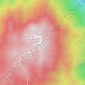
Name: Doi Inthanon topographic map, elevation, terrain.
Location: Doi Inthanon, Mae Chaem, Chiang Mai Province, Thailand (18.58843 98.48741 18.58853 98.48751)
Average elevation: 7,756 ft
Minimum elevation: 5,935 ft
Maximum elevation: 8,392 ft
Make a donation
Gear up for your next adventure:
As an Amazon Associate, this site earns from qualifying purchases at no extra cost to you.