
Thank you for supporting this site ❤️
Make a donation
Make a donation
Gear up for your next adventure:
As an Amazon Associate, this site earns from qualifying purchases at no extra cost to you.
Viguera topographic map
Click on the map to display elevation.
Thank you for supporting this site ❤️
Make a donation
Make a donation
Gear up for your next adventure:
As an Amazon Associate, this site earns from qualifying purchases at no extra cost to you.
About this map
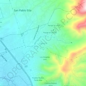
Name: Viguera topographic map, elevation, terrain.
Location: Viguera, Oaxaca de Juárez, Oaxaca, 68016, México (17.10917 -96.77000 17.14917 -96.73000)
Average elevation: 5,541 ft
Minimum elevation: 5,085 ft
Maximum elevation: 6,962 ft
Thank you for supporting this site ❤️
Make a donation
Make a donation
Gear up for your next adventure:
As an Amazon Associate, this site earns from qualifying purchases at no extra cost to you.