
Meadville topographic map
Click on the map to display elevation.
About this map
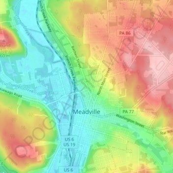
Name: Meadville topographic map, elevation, terrain.
Average elevation: 1,283 ft
Minimum elevation: 1,063 ft
Maximum elevation: 1,565 ft
Crawford County trails, hiking, mountain biking, running and outdoor activities
Other topographic maps
Click on a map to view its topography, its elevation and its terrain.
Teepleville
United States > Pennsylvania > Crawford County > Richmond Township
Average elevation: 1,266 ft
Pymatuning State Park
United States > Pennsylvania > Crawford County > North Shenango Township
Average elevation: 1,086 ft
Hickory Corners
United States > Pennsylvania > Crawford County > Randolph Township
Average elevation: 1,476 ft
Franklin Pike Corners
United States > Pennsylvania > Crawford County > West Mead Township
Average elevation: 1,237 ft