
Thank you for supporting this site ❤️
Make a donation
Make a donation
Gear up for your next adventure:
As an Amazon Associate, this site earns from qualifying purchases at no extra cost to you.
Sur-le-Mont topographic map
Click on the map to display elevation.
Thank you for supporting this site ❤️
Make a donation
Make a donation
Gear up for your next adventure:
As an Amazon Associate, this site earns from qualifying purchases at no extra cost to you.
About this map
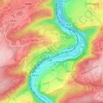
Name: Sur-le-Mont topographic map, elevation, terrain.
Location: Sur-le-Mont, Tilff, Esneux, Luik, Wallonië, 4130, België (50.55303 5.56561 50.59303 5.60561)
Average elevation: 591 ft
Minimum elevation: 203 ft
Maximum elevation: 899 ft
Thank you for supporting this site ❤️
Make a donation
Make a donation
Gear up for your next adventure:
As an Amazon Associate, this site earns from qualifying purchases at no extra cost to you.
Other topographic maps
Click on a map to view its topography, its elevation and its terrain.