
Make a donation
Gear up for your next adventure:
As an Amazon Associate, this site earns from qualifying purchases at no extra cost to you.
Cerro Azul topographic map
Click on the map to display elevation.
Make a donation
Gear up for your next adventure:
As an Amazon Associate, this site earns from qualifying purchases at no extra cost to you.
About this map
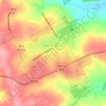
Name: Cerro Azul topographic map, elevation, terrain.
Average elevation: 912 ft
Minimum elevation: 673 ft
Maximum elevation: 1,053 ft
Make a donation
Gear up for your next adventure:
As an Amazon Associate, this site earns from qualifying purchases at no extra cost to you.
Other topographic maps
Click on a map to view its topography, its elevation and its terrain.
Sierra del Imán
Argentina > Misiones > Departamento Leandro N. Alem
La elevación de estas sierras es de unos 700 a 800 m s. n. m., las mismas se encuentran ubicadas en la denominada Meseta misionera o Sierra de Misiones. La sierra que mide unos 50 km de largo, forma un arco que corre aproximadamente en dirección suroeste-noreste desde el departamento de Leandro N. Alem hasta…
Average elevation: 860 ft