Geolocate

Brighton topographic map

Click on the map to display elevation.

About this map

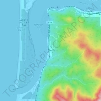
Name: Brighton topographic map, elevation, terrain.

Location: Brighton, Tillamook County, Oregon, 97147, United States (45.65233 -123.94291 45.69233 -123.90291)

Average elevation: 200 ft

Minimum elevation: -10 ft

Maximum elevation: 1,047 ft

Tillamook County trails, hiking, mountain biking, running and outdoor activities

Gear up for your next adventure:

🎒Trekking Poles - Sturdy poles for balance and stability on rough terrain
🪶Thermal Camp Blanket - Extra warmth for cold nights
📡GPS Antenna Upgrade - Enhance GPS reception in remote terrain
🎒Hydration Pack - Hands‑free water reservoir for long hikes
👟Trail Running Shoes - Lightweight shoes for trail runners

As an Amazon Associate, this site earns from qualifying purchases at no extra cost to you.