
Thank you for supporting this site ❤️
Make a donation
Make a donation
Gear up for your next adventure:
As an Amazon Associate, this site earns from qualifying purchases at no extra cost to you.
Miraflores topographic map
Click on the map to display elevation.
Thank you for supporting this site ❤️
Make a donation
Make a donation
Gear up for your next adventure:
As an Amazon Associate, this site earns from qualifying purchases at no extra cost to you.
About this map
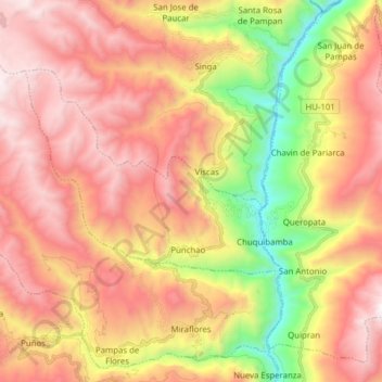
Name: Miraflores topographic map, elevation, terrain.
Location: Miraflores, Provincia de Huamalíes, Huánuco, Perú (-9.50988 -76.93634 -9.36768 -76.78114)
Average elevation: 12,192 ft
Minimum elevation: 8,878 ft
Maximum elevation: 14,816 ft
Thank you for supporting this site ❤️
Make a donation
Make a donation
Gear up for your next adventure:
As an Amazon Associate, this site earns from qualifying purchases at no extra cost to you.