
Make a donation
Gear up for your next adventure:
As an Amazon Associate, this site earns from qualifying purchases at no extra cost to you.
Olá topographic map
Click on the map to display elevation.
Make a donation
Gear up for your next adventure:
As an Amazon Associate, this site earns from qualifying purchases at no extra cost to you.
About this map
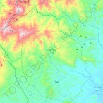
Name: Olá topographic map, elevation, terrain.
Location: Olá, Coclé, Panama (8.36788 -80.78492 8.62896 -80.56228)
Average elevation: 1,388 ft
Minimum elevation: 52 ft
Maximum elevation: 5,466 ft
Make a donation
Gear up for your next adventure:
As an Amazon Associate, this site earns from qualifying purchases at no extra cost to you.
Other topographic maps
Click on a map to view its topography, its elevation and its terrain.
Loma Grande
Panama > Coclé > Distrito Penonomé > Chiguirí Arriba > Loma Grande
Average elevation: 2,096 ft
Make a donation
Gear up for your next adventure:
As an Amazon Associate, this site earns from qualifying purchases at no extra cost to you.