
Make a donation
Gear up for your next adventure:
As an Amazon Associate, this site earns from qualifying purchases at no extra cost to you.
Mount Carmel topographic map
Click on the map to display elevation.
Make a donation
Gear up for your next adventure:
As an Amazon Associate, this site earns from qualifying purchases at no extra cost to you.
Mount Carmel
Sawmill operator, Albert Bradford, gave Mount Carmel its name because of its elevation and beautiful setting in the mountains. He decided that it deserved a special name and named it after the holy mountain in Israel. Mount Carmel began as a logging town. Coal was only discovered in 1790 by Isaac Tomlinson. It took twenty-four years until the first shipment of anthracite was shipped from the borough. Mount Carmel Inn was opened in 1812 by Richard Yarnall and was strategically located on the Centre Turnpike (also known as the Reading-Sunbury Road or Old Reading Road) halfway between Pottsville and Danville. During the latter part of 1854, the Philadelphia and Sunbury Railroad was completed from Shamokin to Mt. Carmel, which led to the opening and development of a number of collieries in the region. During the same year, the Locust Mountain Coal and Iron Company commenced making extensive openings and improvements upon their valuable coal lands in the vicinity of Mt. Carmel, building coal breakers for two collieries – the Coal Ridge and Locust Mountain collieries. The township was erected in 1854, formed from part of Coal Township; by 1862 the borough was incorporated within the township.
Make a donation
Gear up for your next adventure:
As an Amazon Associate, this site earns from qualifying purchases at no extra cost to you.
About this map
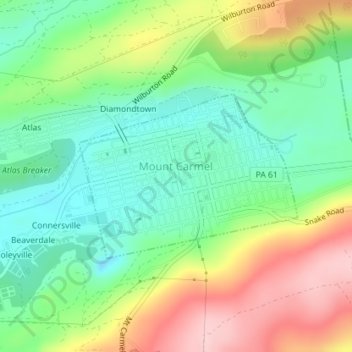
Name: Mount Carmel topographic map, elevation, terrain.
Average elevation: 1,247 ft
Minimum elevation: 994 ft
Maximum elevation: 1,650 ft
Northumberland County trails, hiking, mountain biking, running and outdoor activities
Make a donation
Gear up for your next adventure:
As an Amazon Associate, this site earns from qualifying purchases at no extra cost to you.
Other topographic maps
Click on a map to view its topography, its elevation and its terrain.
Overlook
United States > Pennsylvania > Northumberland County > Ralpho Township
Average elevation: 856 ft
Bear Gap
United States > Pennsylvania > Northumberland County > Ralpho Township > Bear Gap
Average elevation: 1,040 ft
Make a donation
Gear up for your next adventure:
As an Amazon Associate, this site earns from qualifying purchases at no extra cost to you.
Fishers Ferry
United States > Pennsylvania > Northumberland County > Fishers Ferry
Average elevation: 551 ft
Make a donation
Gear up for your next adventure:
As an Amazon Associate, this site earns from qualifying purchases at no extra cost to you.