Geolocate

Eastern topographic map

Click on the map to display elevation.

About this map

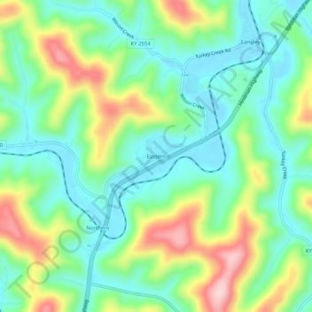
Name: Eastern topographic map, elevation, terrain.

Location: Eastern, Floyd County, Kentucky, 41622, United States (37.49704 -82.82599 37.53704 -82.78599)

Average elevation: 899 ft

Minimum elevation: 643 ft

Maximum elevation: 1,421 ft

Floyd County trails, hiking, mountain biking, running and outdoor activities

Other topographic maps

Click on a map to view its topography, its elevation and its terrain.

Prestonsburg

United States > Kentucky > Floyd County

Average elevation: 899 ft

Wayland

United States > Kentucky > Floyd County

Average elevation: 1,060 ft

Wheelwright

United States > Kentucky > Floyd County

Average elevation: 1,460 ft

Gear up for your next adventure:

🌡️Handheld Weather Meters - Measure wind, temp, and pressure for safe mountain travel
🪑Ultralight Camp Chairs - Portable seating for resting after a long day of mapping
😴Insulated Sleeping Pads - Compact and warm pads for high-elevation camping
👖Convertible Hiking Pants - Versatile zip-off pants for changing altitudes and temperatures
🛰️Satellite Messengers - Emergency SOS and two-way messaging for off-grid adventures

As an Amazon Associate, this site earns from qualifying purchases at no extra cost to you.