
Ixtlahuacán del Río topographic map
Interactive map
Click on the map to display elevation.
About this map
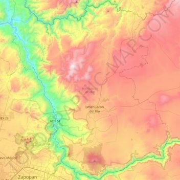
Name: Ixtlahuacán del Río topographic map, elevation, terrain.
Location: Ixtlahuacán del Río, Jalisco, México (20.71436 -103.36995 21.09422 -103.06977)
Average elevation: 5,210 ft
Minimum elevation: 2,644 ft
Maximum elevation: 7,779 ft
Other topographic maps
Click on a map to view its topography, its elevation and its terrain.
Cerro de La Higuera
México > Jalisco > Ixtlahuacán del Río
Cerro de La Higuera, Ixtlahuacán del Río, Jalisco, 45280, México
Average elevation: 6,017 ft