
Hadley topographic map
Click on the map to display elevation.
Hadley
According to the United States Census Bureau, the town has a total area of 24.6 square miles (63.7 km2), of which 23.1 square miles (59.8 km2) is land and 1.5 square miles (3.9 km2), or 6.18%, is water. The land boundaries of Hadley are Sunderland to the north, Amherst to the east, and South Hadley to the south. Across the Connecticut River, Hadley borders Hatfield to the northwest, Northampton to the west, and Easthampton and Holyoke along a short length of river to the southwest. The Mount Holyoke Range forms the boundary with South Hadley and is where the highest point of Hadley is found. This is on Mount Hitchcock at an elevation of 990 to 1,000 feet (300 to 300 m). The Metacomet-Monadnock Trail traverses the Holyoke Range with panoramic vistas from several locations.
About this map
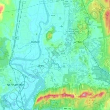
Name: Hadley topographic map, elevation, terrain.
Average elevation: 240 ft
Minimum elevation: 82 ft
Maximum elevation: 1,050 ft
Hampshire County trails, hiking, mountain biking, running and outdoor activities
Other topographic maps
Click on a map to view its topography, its elevation and its terrain.
South Hadley Falls
United States > Massachusetts > Hampshire County > South Hadley
Average elevation: 164 ft
Mill River Recreation Area
United States > Massachusetts > Hampshire County > Amherst > North Amherst
Average elevation: 217 ft
Wildwood Conservation Area
United States > Massachusetts > Hampshire County > Amherst
Average elevation: 292 ft
Worthington Corners
United States > Massachusetts > Hampshire County > Worthington
Average elevation: 1,476 ft