
Mbulu topographic map
Interactive map
Click on the map to display elevation.
About this map
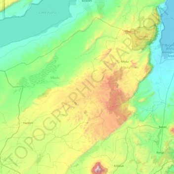
Name: Mbulu topographic map, elevation, terrain.
Location: Mbulu, Manyara, Northern Zone, Tanzania (-4.26323 34.78854 -3.72789 35.73336)
Average elevation: 4,997 ft
Minimum elevation: 3,123 ft
Maximum elevation: 10,906 ft
Other topographic maps
Click on a map to view its topography, its elevation and its terrain.
Tarangire National Park
Tarangire National Park, Babati, Manyara, Northern Zone, Tanzania
Average elevation: 4,108 ft
Lake Manyara
Lake Manyara, Babati, Manyara, Northern Zone, Tanzania
Average elevation: 3,852 ft