
Make a donation
Gear up for your next adventure:
As an Amazon Associate, this site earns from qualifying purchases at no extra cost to you.
Rheinfelden topographic map
Click on the map to display elevation.
Make a donation
Gear up for your next adventure:
As an Amazon Associate, this site earns from qualifying purchases at no extra cost to you.
Rheinfelden
Auf dem Kapuzinerberg, auf einer Höhe von 300 m ü. M., befindet sich eine Messstation des Bundesamtes für Meteorologie und Klimatologie. Dort beträgt die Jahresmitteltemperatur 8,9 °C. Der kälteste Monat ist der Januar mit durchschnittlich −0,1 °C, der wärmste der Juli mit 18,1 °C. Es gibt durchschnittlich 8,8 Hitzetage über 30 °C und 13,0 Eistage unter 0 °C. Die jährliche Niederschlagsmenge beträgt rund 974 mm, wobei besonders in den drei Sommermonaten aufgrund der Konvektion höhere Mengen gemessen werden als während der übrigen Jahreszeiten. Das Maximum wird im August mit 102 mm erreicht, das Minimum im Oktober mit 66 mm.
Make a donation
Gear up for your next adventure:
As an Amazon Associate, this site earns from qualifying purchases at no extra cost to you.
About this map
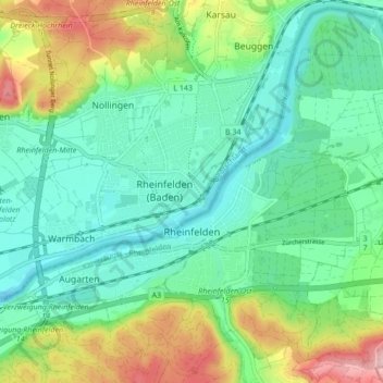
Name: Rheinfelden topographic map, elevation, terrain.
Location: Rheinfelden, Bezirk Rheinfelden, Aargau, 4310, Schweiz (47.53272 7.75284 47.58801 7.83821)
Average elevation: 1,047 ft
Minimum elevation: 850 ft
Maximum elevation: 1,519 ft
Make a donation
Gear up for your next adventure:
As an Amazon Associate, this site earns from qualifying purchases at no extra cost to you.