Geolocate

Ames topographic map

Click on the map to display elevation.

About this map

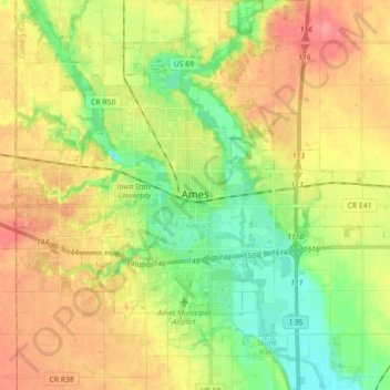
Name: Ames topographic map, elevation, terrain.

Location: Ames, Story County, Iowa, United States (41.97493 -93.69873 42.07795 -93.52143)

Average elevation: 968 ft

Minimum elevation: 856 ft

Maximum elevation: 1,089 ft

Story County trails, hiking, mountain biking, running and outdoor activities

Other topographic maps

Click on a map to view its topography, its elevation and its terrain.

The Horse Shoe Lawn

United States > Iowa > Story County > Ames

Average elevation: 948 ft

Inis Grove Park

United States > Iowa > Story County > Ames

Average elevation: 942 ft

Ontario

United States > Iowa > Story County > Ames

Average elevation: 994 ft

Ada Hayden Lake

United States > Iowa > Story County > Ames

Average elevation: 938 ft

Ames

United States > Iowa > Story County > Ames

Average elevation: 1,010 ft

Gear up for your next adventure:

🩹Survival Bandages - High‑quality bandages for emergencies
🌲Outdoor Survival Books - Best books on survival skills
👟Trail Running Shoes - Lightweight shoes for trail runners
🛠️Backpacking Tool Kit - Essential toolkit for outdoor repairs
🔋Solar Power Banks - Keep your GPS and phone charged in remote wilderness areas

As an Amazon Associate, this site earns from qualifying purchases at no extra cost to you.