
Thank you for supporting this site ❤️
Make a donation
Make a donation
Gear up for your next adventure:
As an Amazon Associate, this site earns from qualifying purchases at no extra cost to you.
Lamerden topographic map
Click on the map to display elevation.
Thank you for supporting this site ❤️
Make a donation
Make a donation
Gear up for your next adventure:
As an Amazon Associate, this site earns from qualifying purchases at no extra cost to you.
About this map
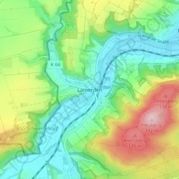
Name: Lamerden topographic map, elevation, terrain.
Location: Lamerden, Liebenau, Landkreis Kassel, Hessen, Deutschland (51.50674 9.30622 51.54674 9.34622)
Average elevation: 705 ft
Minimum elevation: 420 ft
Maximum elevation: 1,253 ft
Thank you for supporting this site ❤️
Make a donation
Make a donation
Gear up for your next adventure:
As an Amazon Associate, this site earns from qualifying purchases at no extra cost to you.
Other topographic maps
Click on a map to view its topography, its elevation and its terrain.
FFH-Gebiet Kalkmagerrasen
Deutschland > Hessen > Landkreis Kassel > Lamerden
Average elevation: 653 ft