
Thank you for supporting this site ❤️
Make a donation
Make a donation
Gear up for your next adventure:
As an Amazon Associate, this site earns from qualifying purchases at no extra cost to you.
Ernstberg topographic map
Click on the map to display elevation.
Thank you for supporting this site ❤️
Make a donation
Make a donation
Gear up for your next adventure:
As an Amazon Associate, this site earns from qualifying purchases at no extra cost to you.
Ernstberg
Im Winter bestehen am Ernstberg bedingt durch die Höhenlage oft gute Wintersportmöglichkeiten. Gespurte Langlauf-Loipen, Rodelhang und Hütte mit Skiverleih sind vorhanden.
Thank you for supporting this site ❤️
Make a donation
Make a donation
Gear up for your next adventure:
As an Amazon Associate, this site earns from qualifying purchases at no extra cost to you.
About this map
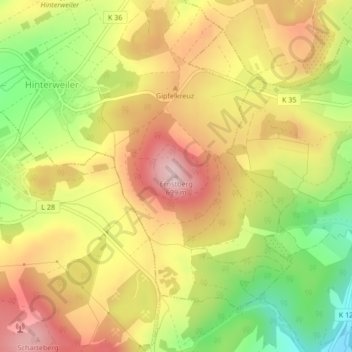
Name: Ernstberg topographic map, elevation, terrain.
Average elevation: 1,923 ft
Minimum elevation: 1,483 ft
Maximum elevation: 2,283 ft
Thank you for supporting this site ❤️
Make a donation
Make a donation
Gear up for your next adventure:
As an Amazon Associate, this site earns from qualifying purchases at no extra cost to you.