Geolocate

Keswick topographic map

Click on the map to display elevation.

About this map

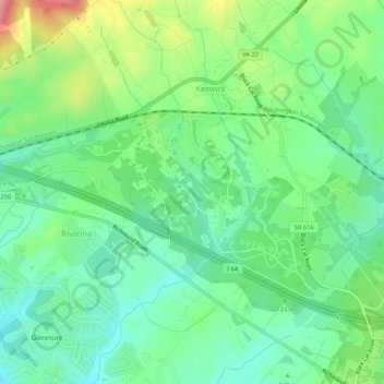
Name: Keswick topographic map, elevation, terrain.

Location: Keswick, Albemarle County, Virginia, United States (37.99763 -78.39089 38.02505 -78.33765)

Average elevation: 417 ft

Minimum elevation: 282 ft

Maximum elevation: 699 ft

Albemarle County trails, hiking, mountain biking, running and outdoor activities

Gear up for your next adventure:

🪵Folding Camp Saw - Compact saw for wood and campsite work
👟Trail Running Shoes - Lightweight shoes for trail runners
👓Polarized Sunglasses - Outdoor sunglasses for glare reduction
🛠️Outdoor Gear Repair Kit - Essential tools to fix gear on the trail
🔌Solar Panel Charger - Charge gear sustainably outdoors

As an Amazon Associate, this site earns from qualifying purchases at no extra cost to you.