
Cuates Butte topographic map
Interactive map
Click on the map to display elevation.
About this map
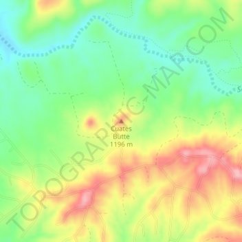
Name: Cuates Butte topographic map, elevation, terrain.
Location: Cuates Butte, Santa Cruz County, Arizona, 85628, VS (31.47116 -110.92292 31.47126 -110.92282)
Average elevation: 3,714 ft
Minimum elevation: 3,524 ft
Maximum elevation: 3,953 ft
Other topographic maps
Click on a map to view its topography, its elevation and its terrain.
Mormon Lake
VS > Arizona > Mormon Lake
Mormon Lake, Coconino County, Arizona, 86038, VS
Average elevation: 7,260 ft
Scottsdale
VS > Arizona > Scottsdale
Scottsdale, Maricopa County, Arizona, VS
Average elevation: 1,834 ft
Saguaro National Park
Saguaro National Park, East Indigo Bush Place, Tucson, Pima County, Arizona, 85748, VS
Average elevation: 3,852 ft
Oljato-Monument Valley
VS > Arizona > Oljato-Monument Valley
Oljato-Monument Valley, Navajo County, Arizona, VS
Average elevation: 5,315 ft