
Make a donation
Gear up for your next adventure:
As an Amazon Associate, this site earns from qualifying purchases at no extra cost to you.
Leavenworth topographic map
Click on the map to display elevation.
Make a donation
Gear up for your next adventure:
As an Amazon Associate, this site earns from qualifying purchases at no extra cost to you.
About this map
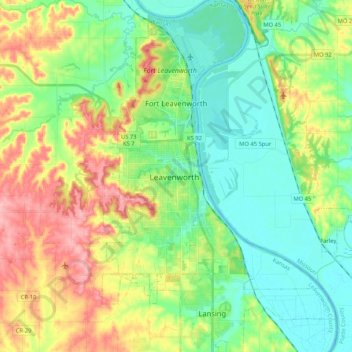
Name: Leavenworth topographic map, elevation, terrain.
Location: Leavenworth, Leavenworth County, Kansas, United States (39.23071 -94.96500 39.39245 -94.88074)
Average elevation: 879 ft
Minimum elevation: 738 ft
Maximum elevation: 1,132 ft
Leavenworth County trails, hiking, mountain biking, running and outdoor activities
Make a donation
Gear up for your next adventure:
As an Amazon Associate, this site earns from qualifying purchases at no extra cost to you.
Other topographic maps
Click on a map to view its topography, its elevation and its terrain.
Leavenworth
United States > Kansas > Leavenworth County > Leavenworth
Leavenworth is located at 39°18′40″N 94°55′21″W / 39.31111°N 94.92250°W / 39.31111; -94.92250 (39.3111112, −94.9224637) at an elevation of 840 feet (256 m).[5] Located in northeastern Kansas at the junction of U.S. Route 73 and Kansas Highway 92 (K-92), Leavenworth is 25 mi (40 km)…
Average elevation: 909 ft