
Make a donation
Gear up for your next adventure:
As an Amazon Associate, this site earns from qualifying purchases at no extra cost to you.
Wandlitz topographic map
Click on the map to display elevation.
Make a donation
Gear up for your next adventure:
As an Amazon Associate, this site earns from qualifying purchases at no extra cost to you.
Wandlitz
„Die Flagge ist Gelb - Blau (1,5:1) gestreift (Bannerform: Streifen senkrecht verlaufend) und mittig im oberen Drittel mit dem Gemeindewappen belegt. Die Höhe des Flaggentuches verhält sich zur Länge wie 5:2.“
Make a donation
Gear up for your next adventure:
As an Amazon Associate, this site earns from qualifying purchases at no extra cost to you.
About this map
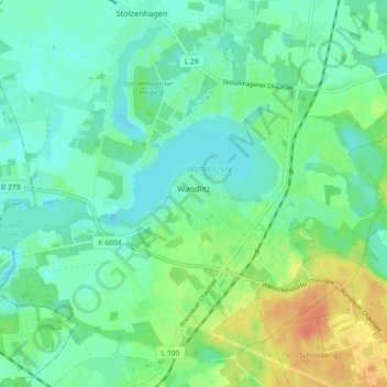
Name: Wandlitz topographic map, elevation, terrain.
Location: Wandlitz, Barnim, Brandenburg, 16348, Deutschland (52.72831 13.40561 52.77746 13.49601)
Average elevation: 187 ft
Minimum elevation: 144 ft
Maximum elevation: 282 ft
Make a donation
Gear up for your next adventure:
As an Amazon Associate, this site earns from qualifying purchases at no extra cost to you.
Other topographic maps
Click on a map to view its topography, its elevation and its terrain.