
Make a donation
Gear up for your next adventure:
As an Amazon Associate, this site earns from qualifying purchases at no extra cost to you.
Nuuk topographic map
Click on the map to display elevation.
Make a donation
Gear up for your next adventure:
As an Amazon Associate, this site earns from qualifying purchases at no extra cost to you.
Nuuk
Nuuk's sports clubs include Nuuk IL (established in 1934), B-67, and GSS Nuuk. Nuuk Stadium is a multi-purpose stadium, used mostly for football games. The stadium has a capacity of 2,000. The stadium can also be used as an entertainment venue: the Scottish rock band Nazareth performed at the venue. Nuuk also has the Godthåbhallen, a handball stadium. It is the home of the Greenland men's national handball team and has a capacity of 1,000. There is a hill for alpine skiing with an altitude difference around 300 meters on the mountain Lille Malene, with the valley station close to the airport terminal. There is also the Nuuk golf course, the only arctic golf course in the world.
Make a donation
Gear up for your next adventure:
As an Amazon Associate, this site earns from qualifying purchases at no extra cost to you.
About this map
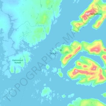
Name: Nuuk topographic map, elevation, terrain.
Location: Nuuk, Sermersooq, 3900, Greenland (64.01670 -51.89614 64.33670 -51.57614)
Average elevation: 249 ft
Minimum elevation: -33 ft
Maximum elevation: 3,839 ft
Make a donation
Gear up for your next adventure:
As an Amazon Associate, this site earns from qualifying purchases at no extra cost to you.
Other topographic maps
Click on a map to view its topography, its elevation and its terrain.
Greenland Ice Sheet
The weight of the ice has depressed the central area of Greenland; the bedrock surface is near sea level over most of the interior of Greenland, but mountains occur around the periphery, confining the sheet along its margins. If the ice suddenly disappeared, Greenland would most probably appear as an…
Average elevation: 2,585 ft
Make a donation
Gear up for your next adventure:
As an Amazon Associate, this site earns from qualifying purchases at no extra cost to you.
Uummannaq Island
The entire island is rocky, with the southern half progressively rising in altitude in the northern direction, towards the Uummannaq Twin Peaks mountain. The area south of the geographical center of the island is a plateau of folded granite hills, dotted with tiny ponds. The plateau falls into the surrounding…
Average elevation: 184 ft
Hans Island
The island itself is barren and uninhabited with an area of 130 ha (320 acres), measuring 1,290 by 1,199 m (4,232 by 3,934 ft), and a maximum elevation of 168.17 m (551.7 ft). Its location in the strait that separates Ellesmere Island of Canada from northern Greenland was for years a border dispute, the…
Average elevation: 33 ft
Make a donation
Gear up for your next adventure:
As an Amazon Associate, this site earns from qualifying purchases at no extra cost to you.
Make a donation
Gear up for your next adventure:
As an Amazon Associate, this site earns from qualifying purchases at no extra cost to you.
Hans Island
Hans Island (Inuktitut and Greenlandic: Tartupaluk, lit. 'kidney shaped'; Inuktitut syllabics: ᑕᕐᑐᐸᓗᒃ; Danish: Hans Ø, pronounced [hanˀs øˀ]; French: île Hans, pronounced [il ɑ̃(n)s]) is an island in the centre of the Kennedy Channel of Nares Strait in the high Arctic region, split between…
Average elevation: 33 ft
Make a donation
Gear up for your next adventure:
As an Amazon Associate, this site earns from qualifying purchases at no extra cost to you.
Greenland
The lowest temperature ever recorded in the Northern Hemisphere was recorded in Greenland, near the topographic summit of the Greenland Ice Sheet, on 22 December 1991, when the temperature reached −69.6 °C (−93.3 °F). In Nuuk, the average daily temperature varies over the seasons from −5.1 to 9.9 °C…
Average elevation: 2,057 ft
Make a donation
Gear up for your next adventure:
As an Amazon Associate, this site earns from qualifying purchases at no extra cost to you.
Make a donation
Gear up for your next adventure:
As an Amazon Associate, this site earns from qualifying purchases at no extra cost to you.
Make a donation
Gear up for your next adventure:
As an Amazon Associate, this site earns from qualifying purchases at no extra cost to you.
Make a donation
Gear up for your next adventure:
As an Amazon Associate, this site earns from qualifying purchases at no extra cost to you.
Make a donation
Gear up for your next adventure:
As an Amazon Associate, this site earns from qualifying purchases at no extra cost to you.
Make a donation
Gear up for your next adventure:
As an Amazon Associate, this site earns from qualifying purchases at no extra cost to you.