Geolocate

Sidney topographic map

Click on the map to display elevation.

About this map

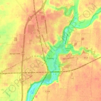
Name: Sidney topographic map, elevation, terrain.

Location: Sidney, Shelby County, Ohio, 45365, United States (40.25400 -84.21629 40.32598 -84.11803)

Average elevation: 1,024 ft

Minimum elevation: 912 ft

Maximum elevation: 1,073 ft

Shelby County trails, hiking, mountain biking, running and outdoor activities

Other topographic maps

Click on a map to view its topography, its elevation and its terrain.

Mount Jefferson

United States > Ohio > Shelby County

Average elevation: 965 ft

Maplewood

United States > Ohio > Shelby County

Average elevation: 1,040 ft

Gear up for your next adventure:

🔦LED Headlamp - Bright and durable LED headlamp for night navigation
🥾Hiking Shoes - Durable and comfortable shoes for trail hiking
🔭Telescopic Hiking Pole - Adjustable pole for hiking stability
🧯Emergency Survival Kit - All‑in‑one survival essentials for the backcountry
🛰️Satellite Messengers - Emergency SOS and two-way messaging for off-grid adventures

As an Amazon Associate, this site earns from qualifying purchases at no extra cost to you.