Geolocate

General Nakar topographic map

Click on the map to display elevation.

About this map

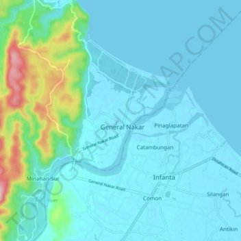
Name: General Nakar topographic map, elevation, terrain.

Location: General Nakar, Quezon, Calabarzon, 4338, Philippines (14.72561 121.59470 14.80561 121.67470)

Average elevation: 118 ft

Minimum elevation: -7 ft

Maximum elevation: 837 ft

Other topographic maps

Click on a map to view its topography, its elevation and its terrain.

Kanan River

Philippines > Quezon > General Nakar

Average elevation: 1,529 ft

Kaliwa River

Philippines > Quezon > General Nakar

Average elevation: 1,299 ft

Gear up for your next adventure:

📱Heavy-Duty Phone Cases - Drop-proof and waterproof protection for outdoor navigation
🥄Camping Utensil Set - Lightweight utensils for outdoor meals
🏕️Family Camping Gear - Essentials for group camping trips
🥇GPS Hiking Watch - Multi‑sport GPS watch with navigation and trail tracking
GPS Sports Watch - GPS watch for running, hiking and training

As an Amazon Associate, this site earns from qualifying purchases at no extra cost to you.