Geolocate

Lower Beechmont topographic map

Click on the map to display elevation.

About this map

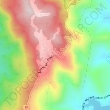
Name: Lower Beechmont topographic map, elevation, terrain.

Location: Lower Beechmont, Gold Coast, Queensland, Australia (-28.05451 153.23943 -28.03451 153.25943)

Average elevation: 974 ft

Minimum elevation: 282 ft

Maximum elevation: 1,680 ft

Other topographic maps

Click on a map to view its topography, its elevation and its terrain.

Reedy Creek

Australia > Queensland > Gold Coast

Average elevation: 52 ft

Kingsholme

Australia > Queensland > Gold Coast

Average elevation: 417 ft

Gear up for your next adventure:

🧭Outdoor Navigation Book - Learn advanced navigation skills
🔦Compact Flashlight - Reliable flashlight for emergencies
📚Navigation Handbooks - Master the art of reading topographic maps and using a compass
🗺️Topographic Maps - Detailed topo maps for hiking, exploring and outdoor navigation
🧤Tactile Hiking Gloves - Keep hands warm while operating GPS and smartphone screens

As an Amazon Associate, this site earns from qualifying purchases at no extra cost to you.