
Thank you for supporting this site ❤️
Make a donation
Make a donation
Gear up for your next adventure:
As an Amazon Associate, this site earns from qualifying purchases at no extra cost to you.
Bogota topographic map
Click on the map to display elevation.
Thank you for supporting this site ❤️
Make a donation
Make a donation
Gear up for your next adventure:
As an Amazon Associate, this site earns from qualifying purchases at no extra cost to you.
About this map
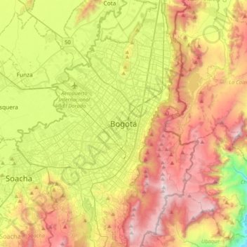
Name: Bogota topographic map, elevation, terrain.
Location: Bogota, Distrito Capital de Bogotá, 110321, Colombia (4.43808 -74.23604 4.75808 -73.91604)
Average elevation: 9,075 ft
Minimum elevation: 5,436 ft
Maximum elevation: 12,126 ft
Thank you for supporting this site ❤️
Make a donation
Make a donation
Gear up for your next adventure:
As an Amazon Associate, this site earns from qualifying purchases at no extra cost to you.