
Bandalungwa topographic map
Interactive map
Click on the map to display elevation.
About this map
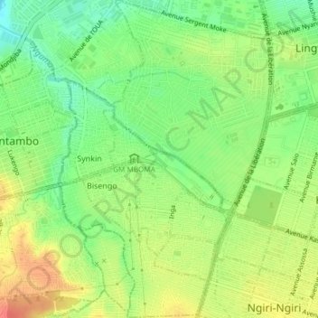
Name: Bandalungwa topographic map, elevation, terrain.
Location: Bandalungwa, Funa, Kinshasa, DR Congo (-4.36031 15.27145 -4.32311 15.29647)
Average elevation: 961 ft
Minimum elevation: 876 ft
Maximum elevation: 1,050 ft
Other topographic maps
Click on a map to view its topography, its elevation and its terrain.
Lukunga
Democratic Republic of the Congo > Kinshasa
Lukunga, Democratic Republic of the Congo
Average elevation: 1,076 ft
Funa
Democratic Republic of the Congo > Kinshasa
Funa, Democratic Republic of the Congo
Average elevation: 1,125 ft