
Funa topographic map
Interactive map
Click on the map to display elevation.
About this map
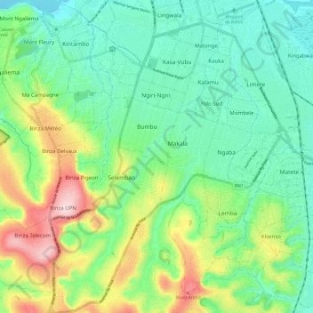
Name: Funa topographic map, elevation, terrain.
Location: Funa, Democratic Republic of the Congo (-4.44206 15.25643 -4.32306 15.32705)
Average elevation: 1,125 ft
Minimum elevation: 830 ft
Maximum elevation: 1,795 ft
Other topographic maps
Click on a map to view its topography, its elevation and its terrain.
Lukunga
Democratic Republic of the Congo > Kinshasa
Lukunga, Democratic Republic of the Congo
Average elevation: 1,076 ft