
Wimberley topographic map
Click on the map to display elevation.
About this map
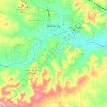
Name: Wimberley topographic map, elevation, terrain.
Location: Wimberley, Hays County, Texas, United States (29.93813 -98.13208 30.01658 -98.04326)
Average elevation: 1,004 ft
Minimum elevation: 787 ft
Maximum elevation: 1,325 ft
Hays County trails, hiking, mountain biking, running and outdoor activities
Other topographic maps
Click on a map to view its topography, its elevation and its terrain.