
Monte Redondo topographic map
Interactive map
Click on the map to display elevation.
About this map
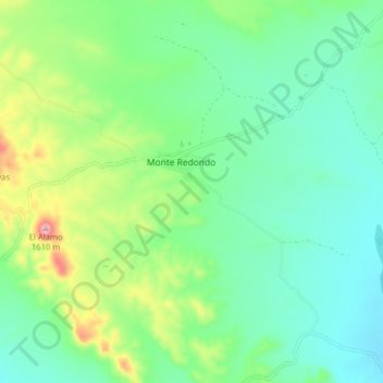
Name: Monte Redondo topographic map, elevation, terrain.
Location: Monte Redondo, Valle de Zaragoza, Chihuahua, México (27.61906 -105.68123 27.63259 -105.60184)
Average elevation: 4,642 ft
Minimum elevation: 4,400 ft
Maximum elevation: 5,285 ft
Other topographic maps
Click on a map to view its topography, its elevation and its terrain.
Hidalgo del Parral
México > Chihuahua > Hidalgo del Parral
Hidalgo del Parral, Chihuahua, 33834, México
Average elevation: 5,922 ft
Chihuahua
México > Chihuahua > Municipio de Chihuahua
Chihuahua, Municipio de Chihuahua, Chihuahua, 31200, México
Average elevation: 5,102 ft
Cuauhtémoc
México > Chihuahua > Cuauhtémoc
Cuauhtémoc, Chihuahua, 31500, México
Average elevation: 6,801 ft
Nariz
México > Chihuahua > Casas Grandes
Nariz, Casas Grandes, Chihuahua, México
Average elevation: 6,811 ft
La Ramada
México > Chihuahua > Valle de Zaragoza
La Ramada, Valle de Zaragoza, Chihuahua, México
Average elevation: 4,833 ft