
Make a donation
Gear up for your next adventure:
As an Amazon Associate, this site earns from qualifying purchases at no extra cost to you.
West Monroe topographic map
Click on the map to display elevation.
Make a donation
Gear up for your next adventure:
As an Amazon Associate, this site earns from qualifying purchases at no extra cost to you.
About this map
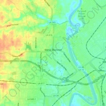
Name: West Monroe topographic map, elevation, terrain.
Location: West Monroe, Ouachita Parish, Louisiana, United States (32.48125 -92.19823 32.55140 -92.11263)
Average elevation: 98 ft
Minimum elevation: 49 ft
Maximum elevation: 171 ft
Ouachita Parish trails, hiking, mountain biking, running and outdoor activities
Make a donation
Gear up for your next adventure:
As an Amazon Associate, this site earns from qualifying purchases at no extra cost to you.
Other topographic maps
Click on a map to view its topography, its elevation and its terrain.
Sherwood Forest
United States > Louisiana > Ouachita Parish > Sherwood Forest
Average elevation: 141 ft
Make a donation
Gear up for your next adventure:
As an Amazon Associate, this site earns from qualifying purchases at no extra cost to you.