
Make a donation
Gear up for your next adventure:
As an Amazon Associate, this site earns from qualifying purchases at no extra cost to you.
Brackwede topographic map
Click on the map to display elevation.
Make a donation
Gear up for your next adventure:
As an Amazon Associate, this site earns from qualifying purchases at no extra cost to you.
Brackwede
Die größte Konzentration öffentlicher Einrichtungen befindet sich auf der Rosenhöhe. Außer den weiter unten beschriebenen Bildungseinrichtungen ist hier vor allem das Klinikum Rosenhöhe der Städtischen Kliniken Bielefeld zu nennen mit medizinischer, chirurgischer, anästhesiologischer, Röntgen- und Hautklinik, einer Augenabteilung und einer Klinik für Geriatrie.
Make a donation
Gear up for your next adventure:
As an Amazon Associate, this site earns from qualifying purchases at no extra cost to you.
About this map
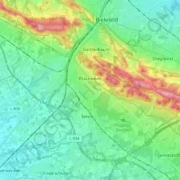
Name: Brackwede topographic map, elevation, terrain.
Location: Brackwede, Bielefeld, Nordrhein-Westfalen, Deutschland (51.94457 8.37782 52.01778 8.53522)
Average elevation: 459 ft
Minimum elevation: 269 ft
Maximum elevation: 1,014 ft
Make a donation
Gear up for your next adventure:
As an Amazon Associate, this site earns from qualifying purchases at no extra cost to you.
Other topographic maps
Click on a map to view its topography, its elevation and its terrain.
Burg und Festung Sparrenberg
Deutschland > Nordrhein-Westfalen > Bielefeld
Um den Erhalt und die Sanierung der Anlage finanziell sicherzustellen, wurde die Aktion Ein Stein für die Burg initiiert, bei der gegen Geldspenden die Patenschaft für einen Stein in der Burgmauer übernommen werden konnte. Bei höheren Spendensummen war eine persönliche Gravur des Steins möglich.…
Average elevation: 476 ft
Make a donation
Gear up for your next adventure:
As an Amazon Associate, this site earns from qualifying purchases at no extra cost to you.