
Mount Hood topographic map
Click on the map to display elevation.
Mount Hood
Timberline Lodge is a National Historic Landmark located on the southern flank of Mount Hood just below Palmer Glacier, with an elevation of about 6,000 ft (1,800 m).
About this map
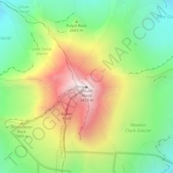
Name: Mount Hood topographic map, elevation, terrain.
Location: Mount Hood, Hood River County, Oregon, United States (45.37346 -121.69593 45.37356 -121.69583)
Average elevation: 8,911 ft
Minimum elevation: 7,260 ft
Maximum elevation: 11,207 ft
Hood River County trails, hiking, mountain biking, running and outdoor activities
Other topographic maps
Click on a map to view its topography, its elevation and its terrain.
Hood River
United States > Oregon > Hood River County
Temperatures for the year as a whole are slightly cooler than in most other low-elevation towns in the region, especially at night because of air drainage off the surrounding mountains.
Average elevation: 367 ft
Wyeth State Recreation Area
United States > Oregon > Hood River County > Cascade Locks
Average elevation: 535 ft