
Make a donation
Gear up for your next adventure:
As an Amazon Associate, this site earns from qualifying purchases at no extra cost to you.
Derry/Londonderry topographic map
Click on the map to display elevation.
Make a donation
Gear up for your next adventure:
As an Amazon Associate, this site earns from qualifying purchases at no extra cost to you.
Derry/Londonderry
Derry is characterised by its distinctively hilly topography. The River Foyle forms a deep valley as it flows through the city, making Derry a place of very steep streets and sudden, startling views. The original walled city of Londonderry lies on a hill on the west bank of the River Foyle. In the past, the river branched and enclosed this wooded hill as an island; over the centuries, however, the western branch of the river dried up and became a low-lying and boggy district that is now called the Bogside.
Make a donation
Gear up for your next adventure:
As an Amazon Associate, this site earns from qualifying purchases at no extra cost to you.
About this map
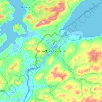
Name: Derry/Londonderry topographic map, elevation, terrain.
Average elevation: 289 ft
Minimum elevation: -16 ft
Maximum elevation: 1,568 ft
Make a donation
Gear up for your next adventure:
As an Amazon Associate, this site earns from qualifying purchases at no extra cost to you.
Other topographic maps
Click on a map to view its topography, its elevation and its terrain.
Drumahoe
United Kingdom > Northern Ireland > County Londonderry > Derry/Londonderry
Average elevation: 151 ft
Causeway Coast and Glens District
United Kingdom > Northern Ireland > County Londonderry
Average elevation: 331 ft
Ballymagroarty
United Kingdom > Northern Ireland > County Londonderry > Derry/Londonderry
Average elevation: 240 ft
Make a donation
Gear up for your next adventure:
As an Amazon Associate, this site earns from qualifying purchases at no extra cost to you.
Mid-Ulster District Council
United Kingdom > Northern Ireland > County Londonderry
Average elevation: 367 ft
Foyle
United Kingdom > Northern Ireland > County Londonderry > Derry/Londonderry
Average elevation: 157 ft
Make a donation
Gear up for your next adventure:
As an Amazon Associate, this site earns from qualifying purchases at no extra cost to you.
Lough Foyle
United Kingdom > Northern Ireland > County Londonderry > Londonderry/Derry
Average elevation: 200 ft
Foyle
United Kingdom > Northern Ireland > County Londonderry > Derry/Londonderry
Average elevation: 157 ft
Bay Road Park
United Kingdom > Northern Ireland > County Londonderry > Derry/Londonderry
Average elevation: 62 ft
Make a donation
Gear up for your next adventure:
As an Amazon Associate, this site earns from qualifying purchases at no extra cost to you.