
Ballinderry topographic map
Click on the map to display elevation.
About this map
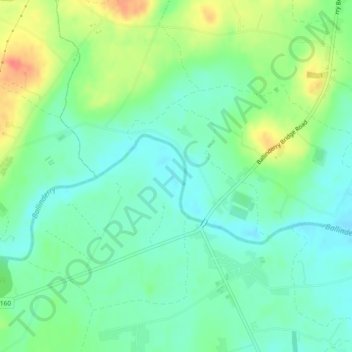
Name: Ballinderry topographic map, elevation, terrain.
Average elevation: 108 ft
Minimum elevation: 49 ft
Maximum elevation: 217 ft
Other topographic maps
Click on a map to view its topography, its elevation and its terrain.
Derry/Londonderry
United Kingdom > Northern Ireland > County Londonderry
Derry is characterised by its distinctively hilly topography. The River Foyle forms a deep valley as it flows through the city, making Derry a place of very steep streets and sudden, startling views. The original walled city of Londonderry lies on a hill on the west bank of the River Foyle. In the past, the…
Average elevation: 289 ft
Drumahoe
United Kingdom > Northern Ireland > County Londonderry > Derry/Londonderry
Average elevation: 151 ft
Causeway Coast and Glens District
United Kingdom > Northern Ireland > County Londonderry
Average elevation: 331 ft
Ballymagroarty
United Kingdom > Northern Ireland > County Londonderry > Derry/Londonderry
Average elevation: 240 ft
Mid-Ulster District Council
United Kingdom > Northern Ireland > County Londonderry
Average elevation: 367 ft
Magilligan - Benone Strand
United Kingdom > Northern Ireland > County Londonderry > Castlerock > Downhill
Average elevation: 72 ft
Lough Foyle
United Kingdom > Northern Ireland > County Londonderry > Londonderry/Derry
Average elevation: 200 ft
Slaughtneil
United Kingdom > Northern Ireland > County Londonderry > Slaughtneil
Average elevation: 446 ft
Eglinton Registrars District
United Kingdom > Northern Ireland > County Londonderry > Greysteel
Average elevation: 285 ft
Derry/Londonderry
United Kingdom > Northern Ireland > County Londonderry
Derry is characterised by its distinctively hilly topography. The River Foyle forms a deep valley as it flows through the city, giving it a steep topography. The original walled city of Londonderry lies on a hill on the west bank of the River Foyle. In the past, the river branched and enclosed this hill as an…
Average elevation: 289 ft
Derry/Londonderry
United Kingdom > Northern Ireland > County Londonderry
Derry is characterised by its distinctively hilly topography. The River Foyle forms a deep valley as it flows through the city, making Derry a place of very steep streets and sudden, startling views. The original walled city of Londonderry lies on a hill on the west bank of the River Foyle. In the past, the…
Average elevation: 289 ft
Derry/Londonderry
United Kingdom > Northern Ireland > County Londonderry
Derry is characterised by its distinctively hilly topography. The River Foyle forms a deep valley as it flows through the city, giving it a steep topography. The original walled city of Londonderry lies on a hill on the west bank of the River Foyle. In the past, the river branched and enclosed this hill as an…
Average elevation: 289 ft