Geolocate

Siesta Key topographic map

Click on the map to display elevation.

About this map

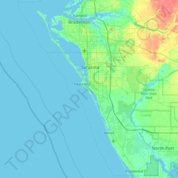
Name: Siesta Key topographic map, elevation, terrain.

Location: Siesta Key, Sarasota County, Florida, 34242, USA (26.93718 -82.85569 27.57718 -82.21569)

Average elevation: 16 ft

Minimum elevation: -10 ft

Maximum elevation: 135 ft

Other topographic maps

Click on a map to view its topography, its elevation and its terrain.

Lake Tarpon

USA > Florida > Lake Shore Estates

Average elevation: 26 ft

Lake Kissimmee

USA > Florida

Average elevation: 56 ft

Julington Creek

USA > Florida > Jacksonville

Average elevation: 20 ft

Gear up for your next adventure:

🔭Stargazing Telescopes - Perfect for camping in low-light pollution areas shown on maps
🥾Women's Hiking Boots - Top-rated trail boots with ankle support and superior grip
🧦Merino Wool Socks - Moisture-wicking, blister-preventing socks for long treks
📷Action Cameras - Rugged cameras to document your journeys across rugged terrain
📶Vehicle Signal Boosters - Improve reception in rural areas while driving to trailheads

As an Amazon Associate, this site earns from qualifying purchases at no extra cost to you.