
Mariveles topographic map
Click on the map to display elevation.
Mariveles
Mariveles features a diverse and dynamic topography characterized by its mountainous terrain and coastal landscapes. The region is dominated by the prominent Mount Mariveles, a stratovolcano that reaches an elevation of approximately 4,531 feet (1,388 meters) at its highest point. The mountain is part of a larger caldera complex, which includes several other peaks, creating a dramatic skyline that slopes down to the surrounding areas. The base of the volcano spans about 14 miles (22 kilometers) in diameter, contributing to a varied landscape that includes steep slopes, valleys, and low-lying coastal areas. The elevation in Mariveles averages around 272 feet (83 meters), but it ranges significantly, with coastal regions at sea level and the mountainous areas offering striking elevation changes. This varied topography not only enhances the natural beauty of the area but also supports a rich biodiversity and numerous recreational opportunities.
About this map
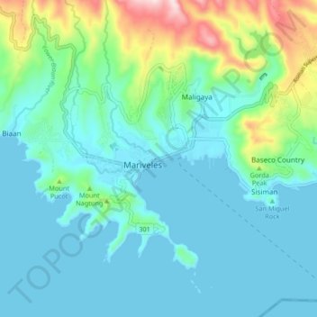
Name: Mariveles topographic map, elevation, terrain.
Location: Mariveles, Bataan, Central Luzon, 2105, Philippines (14.39561 120.45035 14.47561 120.53035)
Average elevation: 272 ft
Minimum elevation: 0 ft
Maximum elevation: 1,414 ft