Geolocate

Havelock topographic map

Click on the map to display elevation.

About this map

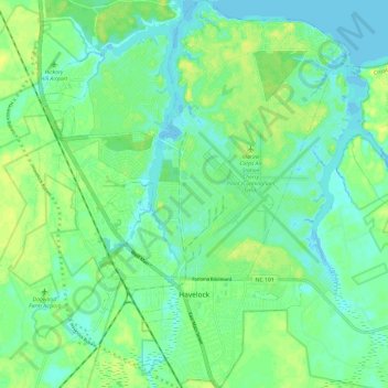
Name: Havelock topographic map, elevation, terrain.

Location: Havelock, Craven County, North Carolina, United States (34.85483 -76.94854 34.95293 -76.85322)

Average elevation: 26 ft

Minimum elevation: -10 ft

Maximum elevation: 59 ft

Craven County trails, hiking, mountain biking, running and outdoor activities

Other topographic maps

Click on a map to view its topography, its elevation and its terrain.

Gear up for your next adventure:

☀️Outdoor Sunscreen - High protection sunscreen for outdoor activities
🧭Map Reading Tools - Tools and kits for map navigation
🕶️Glacier Sunglasses - Side shields to protect eyes from high-altitude snow glare
Backpacking Tents - Weight-optimized shelters for multi-day topographic surveys
🎒Gear Packing Cubes - Organize your backpack efficiently

As an Amazon Associate, this site earns from qualifying purchases at no extra cost to you.