Geolocate

Clover topographic map

Click on the map to display elevation.

About this map

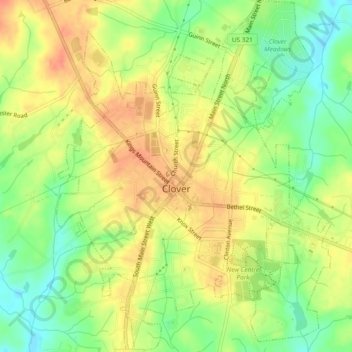
Name: Clover topographic map, elevation, terrain.

Location: Clover, York County, South Carolina, United States (35.09346 -81.24254 35.13183 -81.20580)

Average elevation: 768 ft

Minimum elevation: 682 ft

Maximum elevation: 833 ft

York County trails, hiking, mountain biking, running and outdoor activities

Other topographic maps

Click on a map to view its topography, its elevation and its terrain.

Lake Wylie

United States > South Carolina > York County

Average elevation: 617 ft

Blairsville

United States > South Carolina > York County

Average elevation: 577 ft

Pineview

United States > South Carolina > York County > York

Average elevation: 712 ft

Gear up for your next adventure:

🚑Emergency Bivvies - Heat-reflective sleeping bags for survival situations
👖Convertible Hiking Pants - Versatile zip-off pants for changing altitudes and temperatures
☀️Outdoor Sunscreen - High protection sunscreen for outdoor activities
🔭Telescopic Hiking Pole - Adjustable pole for hiking stability
🧤Hiking Gloves - Protective gloves for rugged trails

As an Amazon Associate, this site earns from qualifying purchases at no extra cost to you.