
Make a donation
Gear up for your next adventure:
As an Amazon Associate, this site earns from qualifying purchases at no extra cost to you.
Oostrozebeke topographic map
Click on the map to display elevation.
Make a donation
Gear up for your next adventure:
As an Amazon Associate, this site earns from qualifying purchases at no extra cost to you.
Oostrozebeke
Oostrozebeke hoort tot Zandlemig Vlaanderen. Het noordelijk deel is een uitloper van het Plateau van Tielt, het zuidelijk deel is een uitloper van het Hoogland van Hulste. De hoogte bedraagt 10-31 meter. Het langgerekte Oostrozebeke ligt direct ten zuiden van de Mandel, terwijl zich verder naar het zuiden het Kanaal Roeselare-Leie bevindt. Vanuit Meulebeke stroomt de Devebeek zuidwaarts en mondt uit in de Mandel.
Make a donation
Gear up for your next adventure:
As an Amazon Associate, this site earns from qualifying purchases at no extra cost to you.
About this map
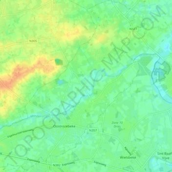
Name: Oostrozebeke topographic map, elevation, terrain.
Location: Oostrozebeke, Tielt, West-Vlaanderen, Vlaanderen, 8780, België (50.90428 3.28612 50.96439 3.37625)
Average elevation: 52 ft
Minimum elevation: 10 ft
Maximum elevation: 118 ft
Make a donation
Gear up for your next adventure:
As an Amazon Associate, this site earns from qualifying purchases at no extra cost to you.