Geolocate

Garfield topographic map

Click on the map to display elevation.

About this map

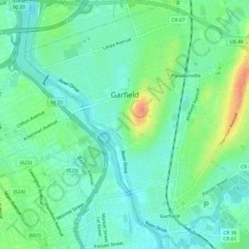
Name: Garfield topographic map, elevation, terrain.

Location: Garfield, Bergen County, New Jersey, 07026, United States (40.86162 -74.13019 40.89371 -74.09196)

Average elevation: 52 ft

Minimum elevation: 3 ft

Maximum elevation: 164 ft

Bergen County trails, hiking, mountain biking, running and outdoor activities

Other topographic maps

Click on a map to view its topography, its elevation and its terrain.

Ridgewood

United States > New Jersey > Bergen County

Average elevation: 184 ft

Darlington

United States > New Jersey > Bergen County > Mahwah

Average elevation: 423 ft

Drag Hill

United States > New Jersey > Bergen County > Mahwah

Average elevation: 827 ft

Stag Hill

United States > New Jersey > Bergen County > Mahwah

Average elevation: 669 ft

Green Hill

United States > New Jersey > Bergen County > Mahwah

Average elevation: 574 ft

Fardale

United States > New Jersey > Bergen County > Mahwah

Average elevation: 407 ft

Cragmere

United States > New Jersey > Bergen County > Mahwah

Average elevation: 446 ft

Teterboro

United States > New Jersey > Bergen County > Teterboro

Average elevation: 39 ft

Westwood

United States > New Jersey > Bergen County > Westwood > Westwood

Average elevation: 102 ft

Glen Rock

United States > New Jersey > Bergen County > Glen Rock > Glen Rock

Average elevation: 171 ft

Hillsdale

United States > New Jersey > Bergen County > Hillsdale > Hillsdale

Average elevation: 131 ft

Gear up for your next adventure:

🛡️Insect Repellent - Protection against bugs during outdoor activities
🪑Ultralight Camp Chairs - Portable seating for resting after a long day of mapping
🪶Thermal Camp Blanket - Extra warmth for cold nights
🪶Fire Starter Kit - Reliable fire starter for survival and camping
☀️Outdoor Sunscreen - High protection sunscreen for outdoor activities

As an Amazon Associate, this site earns from qualifying purchases at no extra cost to you.