
Make a donation
Gear up for your next adventure:
As an Amazon Associate, this site earns from qualifying purchases at no extra cost to you.
Immekeppel topographic map
Click on the map to display elevation.
Make a donation
Gear up for your next adventure:
As an Amazon Associate, this site earns from qualifying purchases at no extra cost to you.
Immekeppel
Die Topographia Ducatus Montani des Erich Philipp Ploennies, Blatt Amt Portz, zeigt das Kirchdorf unter den Namen Immekepel. Carl Friedrich von Wiebeking benennt den auf seiner Charte des Herzogthums Berg 1789 als Imekeppel. Aus ihr geht hervor, dass der Ort zu dieser Zeit Titularort des Kirchspiels Immekeppel war.
Make a donation
Gear up for your next adventure:
As an Amazon Associate, this site earns from qualifying purchases at no extra cost to you.
About this map
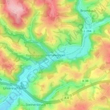
Name: Immekeppel topographic map, elevation, terrain.
Average elevation: 541 ft
Minimum elevation: 285 ft
Maximum elevation: 876 ft
Make a donation
Gear up for your next adventure:
As an Amazon Associate, this site earns from qualifying purchases at no extra cost to you.
Other topographic maps
Click on a map to view its topography, its elevation and its terrain.
Breidenassel
Deutschland > Nordrhein-Westfalen > Rheinisch-Bergischer Kreis > Overath
Average elevation: 597 ft