
Thank you for supporting this site ❤️
Make a donation
Make a donation
Gear up for your next adventure:
As an Amazon Associate, this site earns from qualifying purchases at no extra cost to you.
Caranqui topographic map
Click on the map to display elevation.
Thank you for supporting this site ❤️
Make a donation
Make a donation
Gear up for your next adventure:
As an Amazon Associate, this site earns from qualifying purchases at no extra cost to you.
About this map
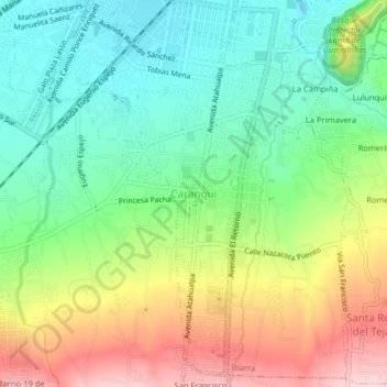
Name: Caranqui topographic map, elevation, terrain.
Location: Caranqui, Ibarra, Imbabura, 100109, Ecuador (0.30312 -78.14355 0.34312 -78.10355)
Average elevation: 7,559 ft
Minimum elevation: 7,205 ft
Maximum elevation: 8,133 ft
Thank you for supporting this site ❤️
Make a donation
Make a donation
Gear up for your next adventure:
As an Amazon Associate, this site earns from qualifying purchases at no extra cost to you.
Other topographic maps
Click on a map to view its topography, its elevation and its terrain.
Parque Ciudad Blanca
Ecuador > Imbabura > Ibarra > Ibarra > Colinas Del Sur
Average elevation: 7,280 ft