
Make a donation
Gear up for your next adventure:
As an Amazon Associate, this site earns from qualifying purchases at no extra cost to you.
Knesselare topographic map
Click on the map to display elevation.
Make a donation
Gear up for your next adventure:
As an Amazon Associate, this site earns from qualifying purchases at no extra cost to you.
Knesselare
Knesselare ligt in Zandig Vlaanderen op een hoogte van ongeveer 15 meter. In het zuiden ligt het Kanaal Gent-Brugge. Hier is de hoogte ongeveer 12 meter. In het noorden ligt de cuesta van Oedelem-Zomergem met een hoogte tot 22 meter. In het noordoosten ligt het Drongengoedbos. Een belangrijke waterloop is de Slabbaartsbeek.
Make a donation
Gear up for your next adventure:
As an Amazon Associate, this site earns from qualifying purchases at no extra cost to you.
About this map
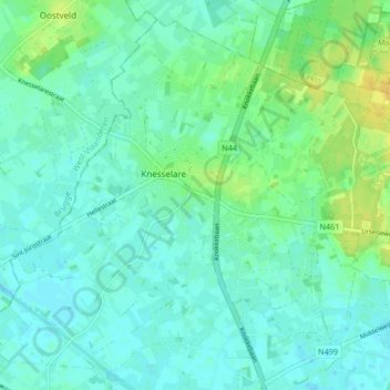
Name: Knesselare topographic map, elevation, terrain.
Location: Knesselare, Aalter, Gent, Oost-Vlaanderen, 9910, België (51.11285 3.36803 51.15990 3.45138)
Average elevation: 39 ft
Minimum elevation: 16 ft
Maximum elevation: 79 ft
Make a donation
Gear up for your next adventure:
As an Amazon Associate, this site earns from qualifying purchases at no extra cost to you.
Other topographic maps
Click on a map to view its topography, its elevation and its terrain.