Geolocate

Leipzig topographic map

Click on the map to display elevation.

About this map

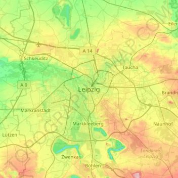
Name: Leipzig topographic map, elevation, terrain.

Location: Leipzig, Saxony, 04109, Germany (51.18063 12.21473 51.50063 12.53473)

Average elevation: 417 ft

Minimum elevation: 230 ft

Maximum elevation: 738 ft

Other topographic maps

Click on a map to view its topography, its elevation and its terrain.

04158

Germany > Saxony > Leipzig

Average elevation: 430 ft

Tensa

Germany > Saxony > Leipzig

Average elevation: 440 ft

04103

Germany > Saxony > Leipzig

Average elevation: 397 ft

Tensa

Germany > Saxony > Leipzig

Average elevation: 440 ft

Gear up for your next adventure:

🧥Waterproof Jacket for Hiking - Breathable and rugged rain jacket for outdoor excursions
🎒Outdoor Daypacks - Lightweight backpacks designed for carrying maps and essential gear
🔭Compact Binoculars - HD vision for scouting terrain and identifying distant landmarks
🧣Merino Neck Gaiters - Multi-functional headwear for wind and sun protection
🛏️Cold Weather Sleeping Bag - Warm sleeping bag for cold conditions

As an Amazon Associate, this site earns from qualifying purchases at no extra cost to you.