
Make a donation
Gear up for your next adventure:
As an Amazon Associate, this site earns from qualifying purchases at no extra cost to you.
Wippra topographic map
Click on the map to display elevation.
Make a donation
Gear up for your next adventure:
As an Amazon Associate, this site earns from qualifying purchases at no extra cost to you.
Wippra
Wippra liegt am südöstlichen Harzrand, etwa 13 km nördlich von Sangerhausen, auf etwa 320 m Höhe. Der Ort liegt im Tal der durch Wippra fließenden Wipper und ist umringt von dichten Wäldern. Der Wald war jedoch lange nicht immer so dicht gewachsen wie heute, da der Mansfelder Kupferschieferbergbau große Mengen von Holz sowohl für Stollenbau, als auch für den Schmelzprozess benötigte.
Make a donation
Gear up for your next adventure:
As an Amazon Associate, this site earns from qualifying purchases at no extra cost to you.
About this map
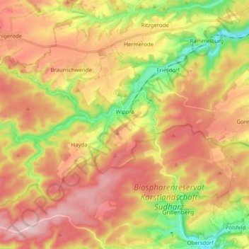
Name: Wippra topographic map, elevation, terrain.
Average elevation: 1,122 ft
Minimum elevation: 682 ft
Maximum elevation: 1,496 ft
Make a donation
Gear up for your next adventure:
As an Amazon Associate, this site earns from qualifying purchases at no extra cost to you.
Other topographic maps
Click on a map to view its topography, its elevation and its terrain.
Popperode
Deutschland > Sachsen-Anhalt > Mansfeld-Südharz > Sangerhausen > Popperode
Average elevation: 1,076 ft