
Make a donation
Gear up for your next adventure:
As an Amazon Associate, this site earns from qualifying purchases at no extra cost to you.
Nieuwerkerken topographic map
Click on the map to display elevation.
Make a donation
Gear up for your next adventure:
As an Amazon Associate, this site earns from qualifying purchases at no extra cost to you.
Nieuwerkerken
Nieuwerkerken is gelegen in Vochtig-Haspengouw. De hoogte bedraagt ongeveer 50 meter. De bodem is opgebouwd uit zand- en kleilagen en het landschap wordt vooral getypeerd door weiden, akkers en boomgaarden. Vroeger bestond er in de wijde omgeving van Nieuwerkerken een uitgestrekt bosgebied, waarvan slechts het kleine Muggenbosje nog een restant is. Ten zuidoosten van Nieuwerkerken, voornamelijk op het grondgebied van de gemeente Sint-Truiden, bevindt zich een groter bosrestant, het tegenwoordige Provinciaal Domein Nieuwenhoven.
Make a donation
Gear up for your next adventure:
As an Amazon Associate, this site earns from qualifying purchases at no extra cost to you.
About this map
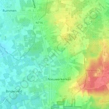
Name: Nieuwerkerken topographic map, elevation, terrain.
Location: Nieuwerkerken, Hasselt, Limburg, Vlaanderen, 3850, België (50.85440 5.17094 50.89454 5.21342)
Average elevation: 148 ft
Minimum elevation: 82 ft
Maximum elevation: 266 ft
Make a donation
Gear up for your next adventure:
As an Amazon Associate, this site earns from qualifying purchases at no extra cost to you.