
Make a donation
Gear up for your next adventure:
As an Amazon Associate, this site earns from qualifying purchases at no extra cost to you.
Oakway topographic map
Click on the map to display elevation.
Make a donation
Gear up for your next adventure:
As an Amazon Associate, this site earns from qualifying purchases at no extra cost to you.
About this map
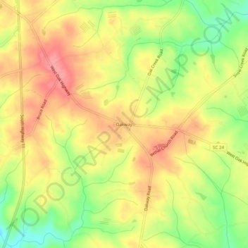
Name: Oakway topographic map, elevation, terrain.
Location: Oakway, Oconee County, South Carolina, United States (34.58121 -83.04571 34.62121 -83.00571)
Average elevation: 925 ft
Minimum elevation: 755 ft
Maximum elevation: 1,053 ft
Oconee County trails, hiking, mountain biking, running and outdoor activities
Make a donation
Gear up for your next adventure:
As an Amazon Associate, this site earns from qualifying purchases at no extra cost to you.
Other topographic maps
Click on a map to view its topography, its elevation and its terrain.
Lake Hartwell State Park
United States > South Carolina > Oconee County > Fairplay Shores
Average elevation: 699 ft