Geolocate

Mitooma topographic map

Click on the map to display elevation.

About this map

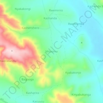
Name: Mitooma topographic map, elevation, terrain.

Location: Mitooma, Ntungamo, Western Region, Uganda (-0.99963 30.38050 -0.95963 30.42050)

Average elevation: 4,734 ft

Minimum elevation: 4,390 ft

Maximum elevation: 5,489 ft

Gear up for your next adventure:

🔥Camping Stove - Portable stove for camping and backcountry cooking
☀️Outdoor Sunscreen - High protection sunscreen for outdoor activities
🪶Trail Camera - Capture wildlife on your hikes
Solar GPS Watches - Advanced multisport watches with built-in topographic maps
📌Outdoor GPS Map App - Apps and devices for digital topographic navigation

As an Amazon Associate, this site earns from qualifying purchases at no extra cost to you.