
Make a donation
Gear up for your next adventure:
As an Amazon Associate, this site earns from qualifying purchases at no extra cost to you.
Repalle topographic map
Click on the map to display elevation.
Make a donation
Gear up for your next adventure:
As an Amazon Associate, this site earns from qualifying purchases at no extra cost to you.
Repalle
Repalle is located at 16°01′N 80°31′E / 16.01°N 80.51°E / 16.01; 80.51. It has an average elevation of 7 m (23 ft) and situated 10.62 km (6.60 mi). The nearest towns are Tenali in the Guntur district, Ponnur, Bapatla in the Bapatla District and Machilipatnam in the Krishna district.
Make a donation
Gear up for your next adventure:
As an Amazon Associate, this site earns from qualifying purchases at no extra cost to you.
About this map
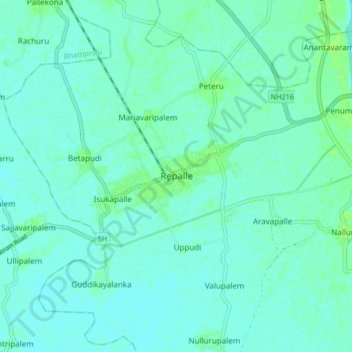
Name: Repalle topographic map, elevation, terrain.
Location: Repalle, Bapatla, Andhra Pradesh, 522265, India (15.97928 80.79146 16.05928 80.87146)
Average elevation: 16 ft
Minimum elevation: 7 ft
Maximum elevation: 36 ft
Make a donation
Gear up for your next adventure:
As an Amazon Associate, this site earns from qualifying purchases at no extra cost to you.